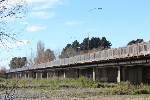
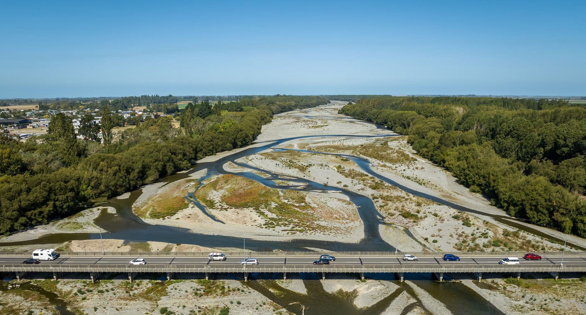
Second Ashburton Bridge
Why do we need a second bridge?
- Safety issues for traffic turning right onto the state highway from east Tinwald
- Delays experienced from the closure of the existing bridge route
- The life of the existing bridge and predicted future growth in Tinwald and Lake Hood
- Traffic congestion at intersections with the state highway and intersections north and south of the existing bridge
- Pedestrian and cyclist issues
Reasons for building a second bridge
A second crossing of the Ashburton River was deemed necessary to:
- Improve road safety for all road users
- Improve connectivity for everybody in the Ashburton urban area
- Meet the current and future needs of the Ashburton district/community
- Provide security for the Ashburton road network and state highway by providing alternative access in the event the current bridge cannot be used
- Ensure that State Highway 1 continues to take inter-district and heavy traffic
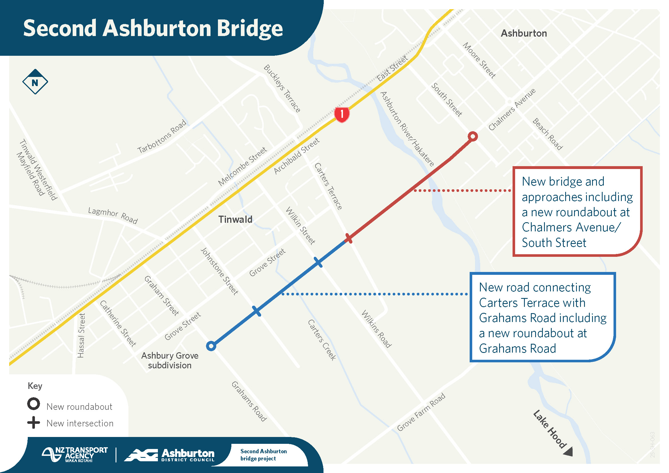
Project Map
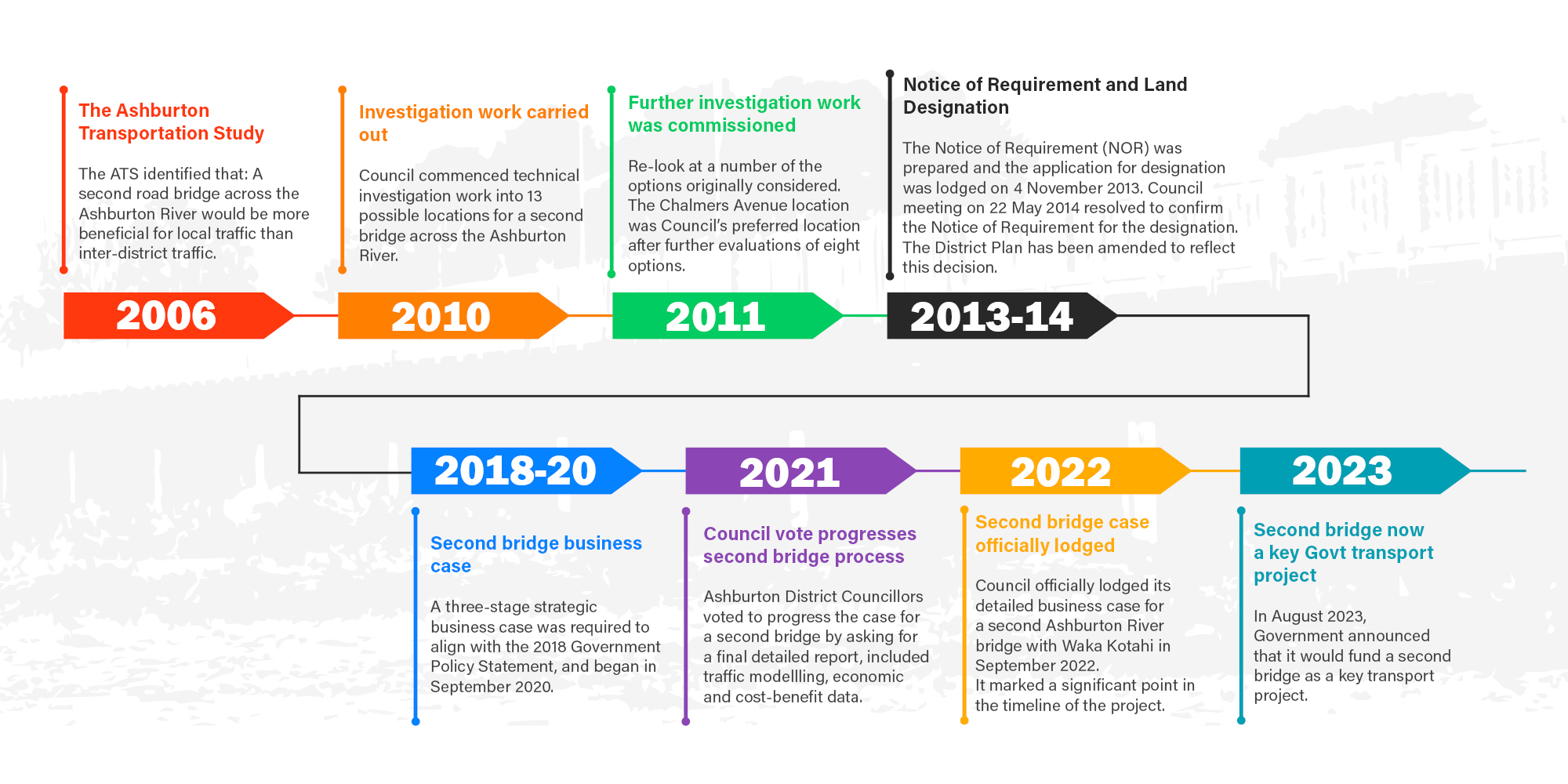
Project Timeline
Find out more and sign up for updates
Project News
Second Ashburton Bridge: Update 18 February 2026
This year marks a big step forward for the Second Ashburton Bridge project. We’re gearing up for construction, and a lot of the work happening now is about setting the project up well so the main build can start smoothly.
Second Ashburton Bridge: Update 19 December 2025
As 2025 wraps up, we’re taking a moment to reflect on what’s been achieved on the Ashburton second bridge project so far and share some of what’s coming up in the new year.
Second Ashburton Bridge: Update on trial pile
We’re getting ready to install a ‘trial pile’ near the Ashburton/Hakatere River as part of early works for the Second Ashburton Bridge. This test helps us understand how the ground behaves so we can design the right foundations to safely support the new bridge.
Ashburton-Tinwald Connectivity Detailed Business Case (prepared by Stantec)
Appendix Documents
The Ashburton Transportation Study 2006
The Ashburton Transportation Study 2006 (ATS) was jointly commissioned by the NZ Transport Agency (Transport Agency) and the Ashburton District Council to identify present and future transportation demands within the Ashburton urban area for the 20 year period through to 2026, and to recommend measures to optimise the performance of the land transport system within the Ashburton township.
The ATS confirmed that:
- A second road bridge across the Ashburton River would be more beneficial for local traffic than inter-district traffic
- There are signficant traffic pressure points from traffic crossing the bridge at peak hours
- These pressure points would become worse as the town continues to grow
- A signficant proportion of traffic crossing the bride was local traffic
- Relieving pressure can only be achieved by providing an alternative route between Tinwald and Ashburton for local traffic
- The study also found Ashburton was vulnerable should the current bridge stop functioning, the nearest alternative is approximately 60km away - to Thompsons Track and back. (further concerns have been raised as a result of the 2010/2011 Canterbury earthquakes)
Traffic modelling work carried out as part of the ATS indicated that traffic flows on key routes through Ashburton are likely to increase signficantly by 2026 regardless of a second bridge. Vehicle number plate surveys were undertaken in 2006 (and repeated in 2012) which confirmed that the bulk of the traffic on the existing bridge during peak times is local traffic travelling between Tinwald and Ashburton. Less than 30% of the traffic is "through traffic" on SH1. The Council and the Transport Agency have agreed the traffic issues on the current bridge is a local traffic issue and the 2nd urban bridge project will predominantly be to serve the local traffic needs of the Tinwald and Ashburton communities.
Investigation work carried out
In 2010 Council commenced technical investigation work into the possible location for a second bridge across the Ashburton River.
An Issues and Options report identified a number of issues regarding the existing bridge, including:
- The likelihood that projected future traffic volumes will exceed the bridge's capacity
- The majority of traffic on the existing bridge is local traffic travelling between Ashburton and Tinwald
- The lack of viable alternative routes should the bridge be closed due to natural events or accidents or other incidents on the bridge
- The vulnerability of the existing structure to natural events
A total of 13 possible bridge locations were considered. Each bridge option was considered against an extensive list of agreed criteria. Public feedback and consultation was undertaken via a public meeting, newsletters, open days and meetings with various stakeholders.
Further investigation work was commissioned in 2011 to re-look at a number of the options originally considered. A multi-criteria assessment was undertaken of each of these options, with each option being assessed against 16 set criteria. As part of this work a community reference group was established and a Social Impact Assessment was also undertaken.
Three options off Chalmers Avenue to the south of the Ashburton River best met the necessary criteria. Further public consultation was undertaken with open days, media and District Diary coverage and a feedback form was circulated to all residents. Of those options, Grove Street scored consistently lower than the east of Tinwald options, consequently Council resolved to focus on the two Chalmers Avenue to east of Tinwald options (an urban option and a rural option).
The Council held landowner only meetings as well as face to face meetings with all potentially affected landowners within the 'corridor' of the proposed routes. Council resolved on 4 July 2013 to a roading alignment proceeding to designation to protect the bridge location and associated road alignment. Further individual meetings were held with the directly affected landowners. Council then agreed at its 3 October 2013 meeting to proceed with the lodgement of the Notice of Requirement (NOR) for land designation .
Notice of Requirement and Land Designation
The designation is a form of "spot-zoning" of the proposed route in the district plan, which authorises the necessary work and reduces the requirement for additonal resource consents. The designation connects the southern end of Chalmers Avenue with a new bridge across the Ashburton River and onto a new two lane road through low density land east of Tinwald to connect with Grahams Road at the south end of Tinwald.
The Notice of Requirement (NOR) was prepared and the application for designation was lodged on 4 November 2013.
A public hearing of submissions was held from 10 March to 14 March 2014 in front of two independent commissioners, Andy Carr and John Milligan. Submitters who presented to the hearing included affected landowners, stakeholder groups and inviduals.
The commissioners recommendations to Council, which took into account the Notice of Requirement, planners' recommendations, the relevant national and regional planning documents and information presented at the hearing were considered at an extraordinary meeting on 22 May 2014.
At the meeting Council resolved to confirm the Notice of Requirement for the designation. The District Plan has been amended to reflect this decision.
After Land Designation
Whilst an important step, the designation process is just part of the ongoing project. Although the physical construction of the bridge and the new road is not expected to start before 2025/26, there are still a number of project stages to be worked through. These will include:
- Continuing discussions with directly affected landowners
- Addressing resource consent requirements
- Developing detailed designs and preparing contracts for construction
- Construction and commissioning of the bridge and route
Investigative Work Documents
Type in keywords to filter the Past Investigation Documents
Type in keywords to filter the Notice of Requirement Documents