Severe Weather in Canterbury
12pm 22/09 Update
Road closure - We are reopening Ashburton Gorge Road at Mt Somers, but we advise to please drive to the conditions as there is scouring in some areas. The road will still be closed however from Mt. Sunday to Erewhon as there's deep water flowing through one of the fords and it has suffered some damage. Crews will be there later in the week to address.
1.30pm - 21/09 Update
Road closure - We are closing Ashburton Gorge Road at Mt Somers due to flooding across the road at Freezing Point. The road will be closed for the rest of the day and overnight. We will assess conditions first thing tomorrow.
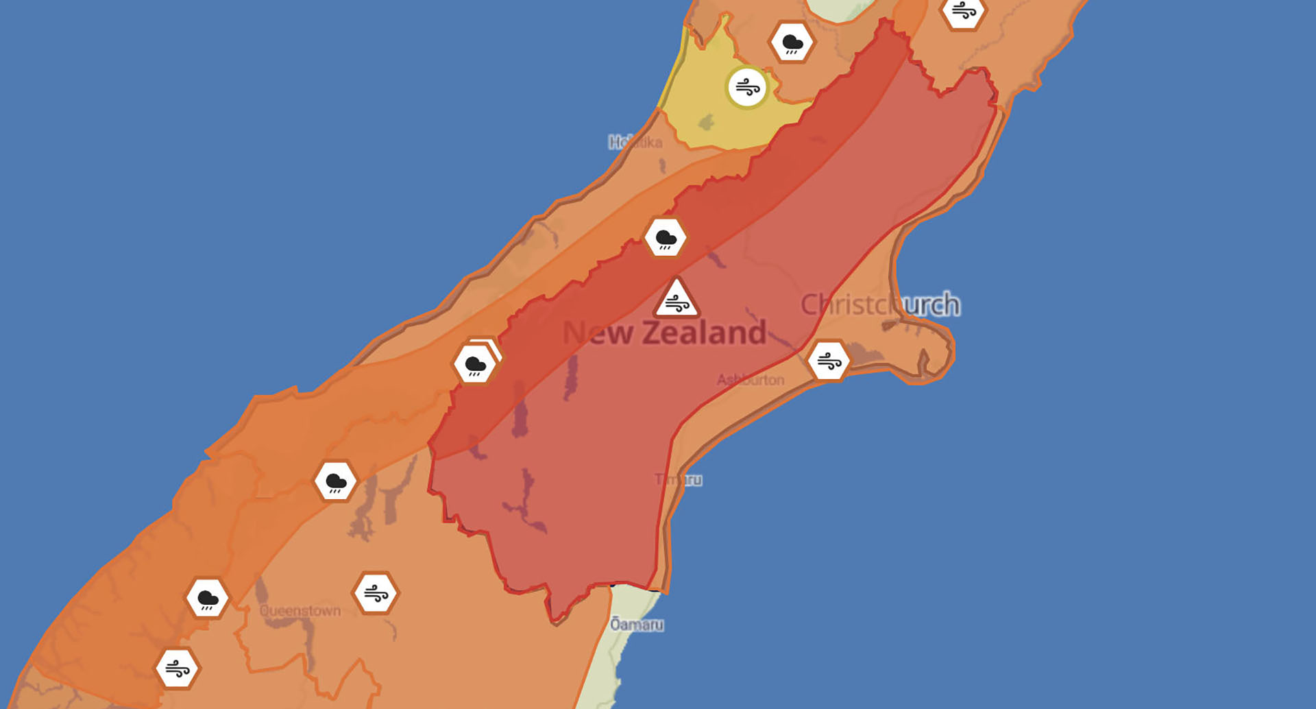
From CDEM Group - Significant wind gusts recorded across Canterbury - wind warning stays in place until 3pm.
Although the wind has not been seen in residential areas as expected, MetService have recorded significant gusts as the weather system moves north across Canterbury.
The severe weather forecaster has confirmed that:
- Geraldine Forest gusted to 189km/h at 4:30am
- Mt Hutt Summit gusted to 220km/h at 4am
- Le Bons Bay (Banks Peninsula) gusted to 115km/h at midnight last night
- Fairlie gusted to 112km/h at 3am last night
- Springfield gusted to 110km/h at 6am this morning
Canterbury Group Controller Phill Mackay says: “Overnight there were significant winds across the region causing power outages and minor damage that we are aware of.”
Mackay wants to remind people that “MetService has amended the wind warning to reflect the northerly direction of travel for the system BUT we are still within a RED WIND warning until 1500 today especially North Canterbury.”
Phill added: “We want to thank Cantabrians for heeding the warning so far it is always important to consider how these winds may impact you and your property and take action to mitigate any impacts.”
“We continue to monitor the situation. If at any time you, your family and/or your property are at risk, immediately contact emergency services on 111.”
4pm - 20/09 Update
Messaging from CDEM Group - MetService has issued a Red Weather Warning for exceptionally strong north to northwest winds across Canterbury from 10pm tonight (Saturday 20 September) through to Sunday afternoon.
Damaging wind gusts of 130–150 km/h are forecast in exposed areas.
Winds of this strength may:
- damage powerlines and roofs
- pose a threat to life from flying debris and falling trees
- cause dangerous driving conditions
- cause significant disruption to transport and power supply.
This event is different from typical wind warnings in Canterbury. Residents and visitors are urged to take this warning seriously and prepare now.
What you should do:
- Charge devices and prepare for possible power outages.
- Secure outdoor items and check your property for anything that could become airborne e.g. trampolines, outdoor furniture, rubbish bins.
- Avoid unnecessary travel from 10pm tonight. If travel is essential, drive to the conditions. High-side vehicles are especially at risk.
- Stay informed via radio, local council Facebook pages, and the CDEM Canterbury website.
- Check any outdoor fire sites from the last two weeks. If you find any heat, smoke, or embers, pour water over the area until it is cold to the touch. Do not light any outdoor fires.
- Do not carry out activities that could cause sparks or ignition outdoors, e.g. using gas cookers.
Canterbury Emergency Management will be working with other agencies to monitor the situation closely.
Updates will be shared across media channels including radio, in case of power outages.
If you, your family, or your property are at risk at any time, call 111 immediately.
3pm - 20/09 Update
Metservice has issued a Red Strong Wind Warning for Canterbury about and west of the foothills, also west of SH1 south of the Rakaia River from 10pm tonight (Saturday) until 3pm on Sunday.
Ashburton District Civil Defence is monitoring the situation and have been meeting with Civil Defence Emergency Management Canterbury Group, NEMA and lifeline agencies.
Damaging gusts of 150 km/h are expected in exposed places, causing threat to life from flying items and falling trees. Destructive winds will cause widespread damage including powerlines and roofs, with dangerous driving conditions and significant disruption to transport and power supply.
Other actions you can take to prepare:
- Bring inside or tie down anything that can be broken or picked up by strong winds, such as outdoor furniture.
- If you have a trampoline, turn it upside down to minimise the surface area exposed to wind
- Remove any debris or loose items from around your property. Branches and firewood may become missiles in strong winds.
- Clear debris and leaves from external drains and gutters to prevent overflow or water damage in heavy rain.
- Bring pets indoors. They can be unsettled by severe weather and it is more comforting and safer for them to be with you.
- Ensure livestock are not gathered under an isolated tree or anything that presents a risk from a lightning strike.
- Moor boats securely or move to a designated safe location.
- Use rope or chain to secure boat trailers. Use tie-downs to anchor a trailer to the ground or to a building.
Fire Hazards
Please check your old burn piles and make sure they are fully extinguished. That means turning the whole pile over to ensure there are no smouldering embers that can reignite with the wind.
For more information:
Radio stations are a vital means of getting the word out and are a great way to stay in the loop, particularly in a power outage. Tune into these radio frequencies for the district.
- Radio NZ 101.3FM
- Hokonui FM - 92.5FM
- Newstalk ZB - 873AM
Weather updates https://www.metservice.com/warnings/
Local road closures http://ashburtondc.govt.nz/road-closure-map
State Highway Closures https://www.journeys.nzta.govt.nz/journey-planner
Power outages https://www.eanetworks.co.nz/power/outages
Alpine river alerts https://www.ecan.govt.nz/home/flood-warning
Ashburton Resource Recovery Park often closes in adverse weather, please phone 03 308 3143 to avoid disappointment.
Share this article
Latest News
Short water shutdown planned in Hinds
Land set to be rezoned for more housing
Detours planned while roundabout repaired
Mayor Liz thanks employers for backing job scheme
Deputy Mayor Richard Wilson: Planning for uncertain times
Road Closures
SPRINGFIELD ROAD WEST
from 7 Apr 6:00 to 20 Apr 18:00
CHERTSEY LINE ROAD
from 7 Apr 21:00 to 10 Apr 5:30
BARING SQUARE EAST
from 7 Apr 7:00 to 21 Apr 18:00
OAK GROVE - HARRISON STREET - BELT ROAD ROUNDABOUT
from 13 Apr 9:00 to 3 May 19:00
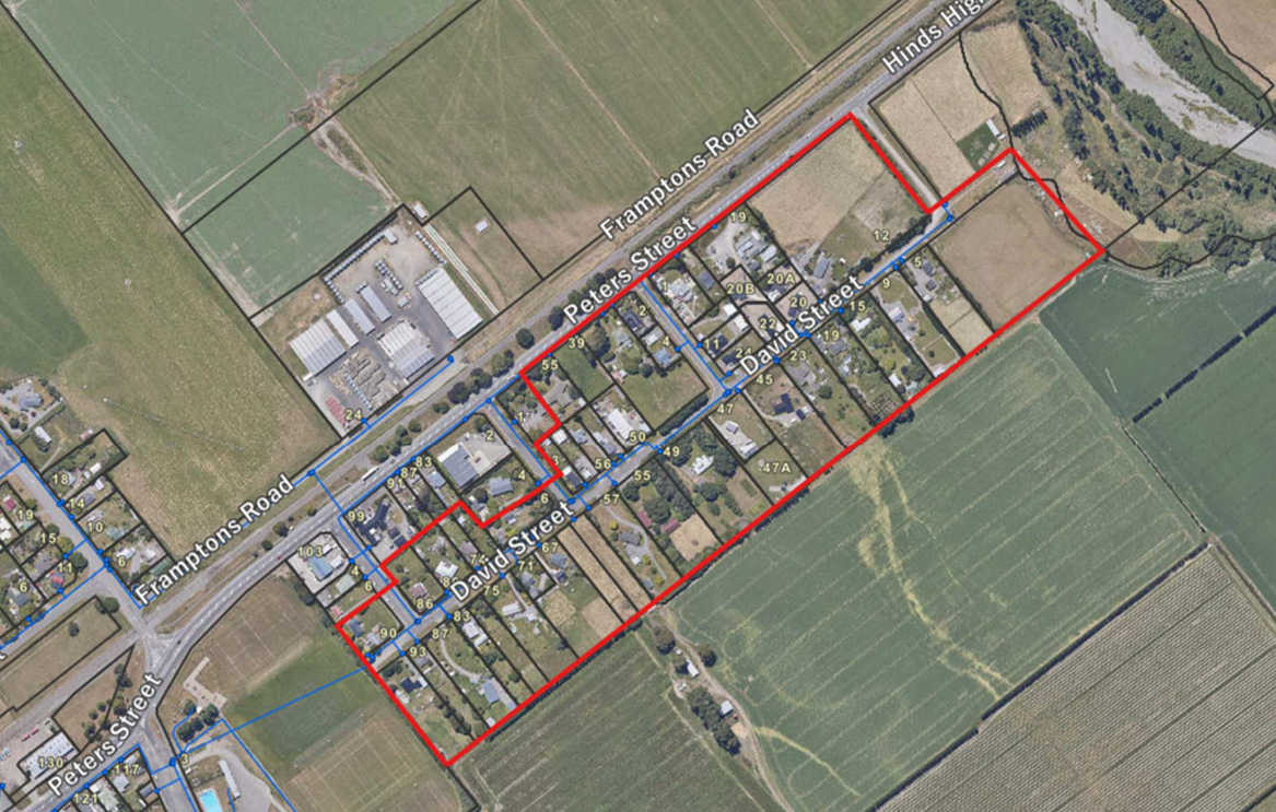
DAVID STREET
from 23 Mar 7:00 to 10 Apr 18:00
View all Road Closures | Live map