Civil Defence monitoring after heavy rain warning issued

Updated 5.00pm, Tuesday 26 July: Ashburton Civil Defence Emergency Management continues to monitor conditions closely, however the District is coping well so far following yesterday's Orange Heavy Rain warning for Mid Canterbury.
As of 9am today, the MetService was warning of a further 80 to 100 mm of rain to accumulate in addition to the 40 to 55 mm which has already fallen.
Ashburton’s Emergency Operations Centre (EOC) is not being activated at this stage, however is on standby and ready to deploy on short notice if required.
Roads
Drivers are encouraged to take extra care on the roads with surface flooding and hazardous road conditions expected.
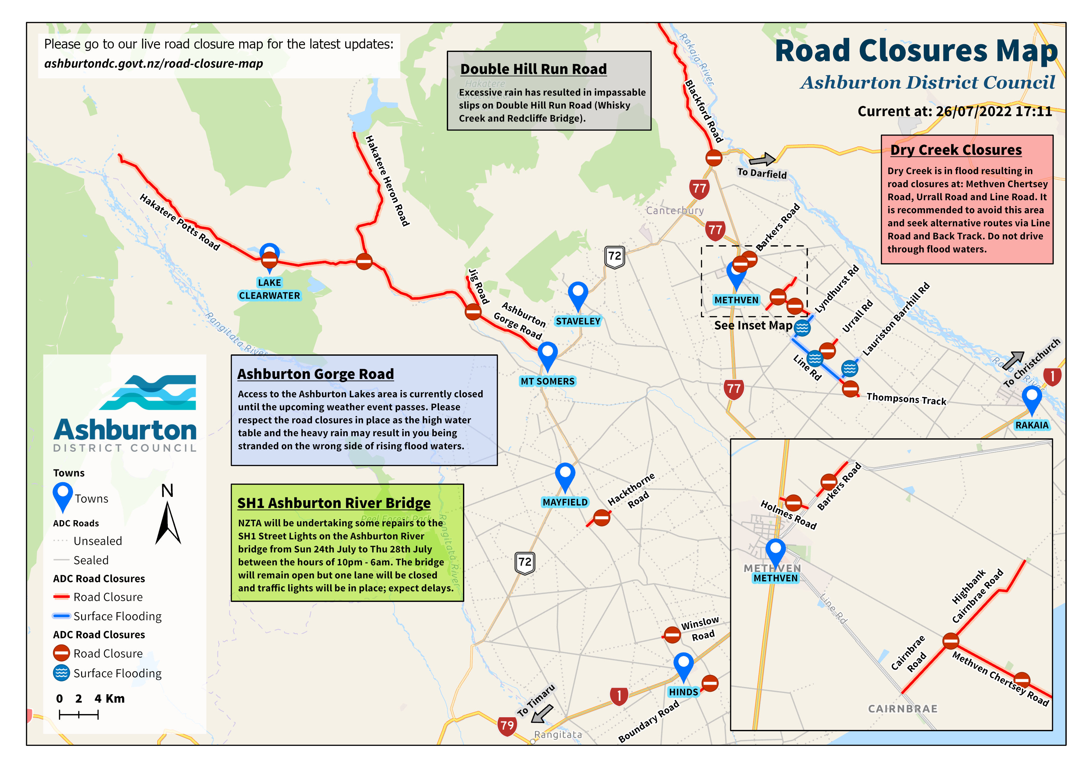
Access to the Ashburton Lakes area via Ashburton Gorge Road is closed until this weather event has passed. All current road closures can be found on the Council’s live road closure map.
The map below shows current road closures as of 5pm, Tuesday 26 July (Click map for full resolution)
Waka Kotahi – NZTA have cleared debris around the rail bridge and SH1 bridge in preparation of the adverse weather.
Rivers
The Ashburton River South Branch, North Branch, Taylors Stream, and Bowyers Stream are all likely to see elevated flows, but Environment Canterbury now expect these to be generally less than those seen last week. Environment Canterbury staff will continue to monitor flows and vulnerable areas of the rivers closely.
Check their website for the latest flood warnings.
Drinking Water
The Council recommends that Methven and Mt Somers residents store drinking water now in case the adverse weather results in a boil water notice for those water supplies.
The boil water notice for the Methven-Springfield scheme remains in place.
Stay Informed
- Text your post code to 4196 for free Council text alerts.
- Use the Snap, Send, Solve app or call 03 307 7700 to report any issues to the Council.
- View the latest MetService Weather Warnings on the MetService website.
- Follow the Council and Canterbury CDEM Facebook pages for further updates.
Share this article
Latest News
Cr Jeanette Maxwell: Hard works pays off over time
Community feedback open on shared spaces
Sandbag stations set up for community ahead of flood events
Applications open for community grants
Awards judges give high praise
Road Closures
JOHNSTONE STREET
from 16 Mar 8:00 to 17 Mar 16:00
TREVORS ROAD
from 2 Mar 7:00 to 19 Apr 19:00
SEAFIELD ROAD
from 2 Mar 7:00 to 19 Apr 19:00
SMALLBONE DRIVE
from 15 Mar 6:00 to 15 Mar 15:00
MOORE STREET
from 3 Mar 6:00 to 6 Mar 18:00
View all Road Closures | Live map